Blog
Dec
The United States has one of largest land masses of any country in the world. Our country has vast mountains, plains, deserts. Puerto Rico—a territory of the United States—is home to the only tropical rain forest in North America. What is all of this land used for? Bloomberg pulled data from a number of sources to determine to answer this question.
Sure, a percentage of land is allotted for residential or business use. With the amount of traffic in some areas, it can seem as if our country is overpopulated; however, as Bloomberg learned from the data, that’s not the case.
Six Land Types
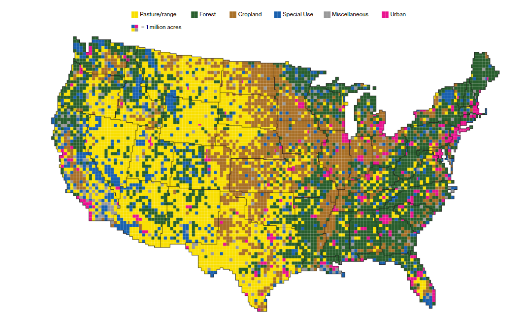
Bloomberg authors Dave Merrill and Lauren Leatherby write, “Using surveys, satellite images and categorizations from various government agencies, the U.S. Department of Agriculture divides the U.S. into six major types of land. The data can’t be pinpointed to a city block—each square on the map represents 250,000 acres of land. But piecing the data together state-by-state can give a general sense of how U.S. land is used”.
These six land types are:
- Pasture/range
- Forest
- Cropland
- Special Use
- Miscellaneous
- Urban
The map clearly shows urban areas are a minority compared to the rest, just by looking at the colored squares. Miscellaneous and special use areas have fewer squares than forest, cropland, or pasture and range zones. Bloomberg was able to collect the acreage for each land type.
Acreages of the Land Types
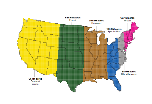
Imagine if you were able to view each land type together on the map. That’s what you get in the photo above. Here, it’s proven that urban areas are indeed the smallest and pasture and ranges are the largest. How many acreages does each land type contain? Here’s the breakdown:
- Urban: 69.4M acres
- Miscellaneous: 68.9M acres
- Special Use: 168.6M acres
- Cropland: 391.5M acres
- Forest: 538.6M acres
- Pasture/range: 654M acres
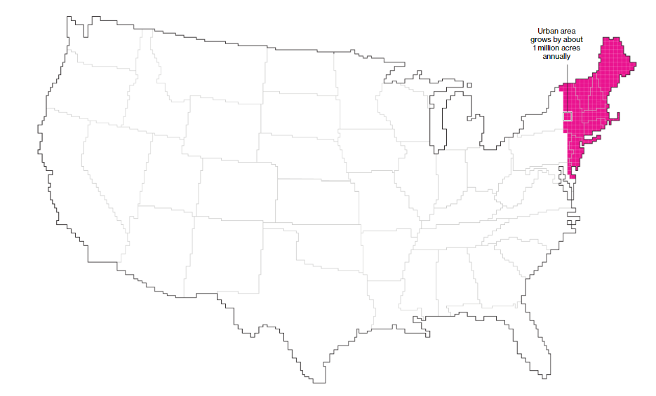
“Four in five Americans live, work and play” in urban areas, write Merrill and Leatherby. Given this fact, most Americans would be able to fit in a relatively small area of the country, in theory. Urban areas are growing quickly, however. Merrill and Leatherby continue, “The U.S. is becoming more urban—at an average rate of about 1 million additional acres a year. That’s the equivalent of adding new urban area the size of Los Angeles, Houston and Phoenix combined. U.S. urban areas have more than quadrupled since 1945”.
Food Production and Land
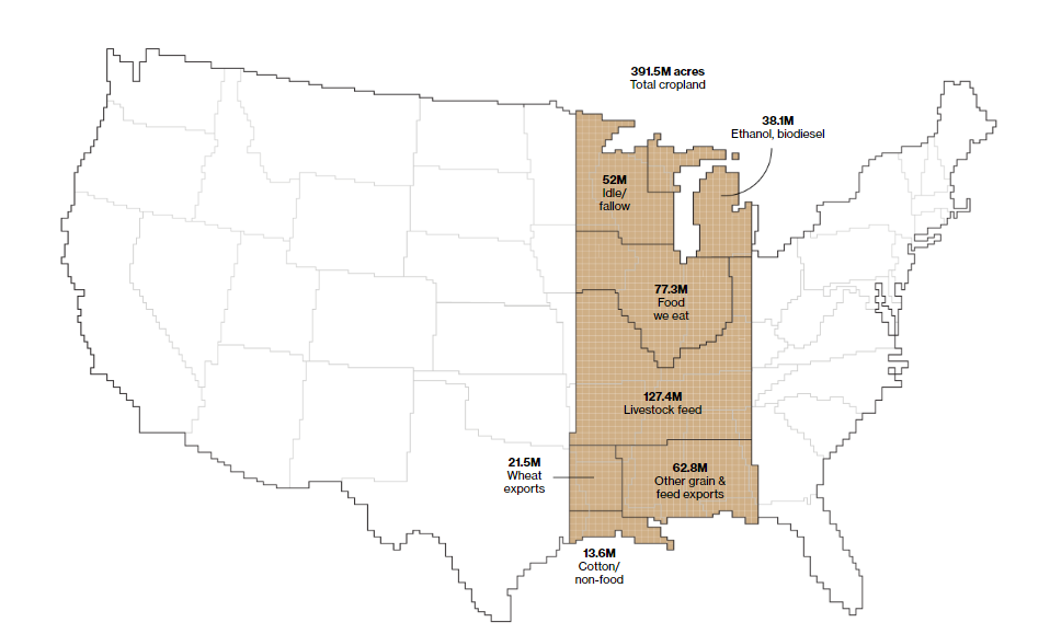
Around one-fifth of the land in our country is agricultural land and most of it is located in the Midwest. However, only a small percentage of agricultural land is currently used to feed Americans. Some of the land is used for ethanol production or livestock feed. Other land is used to cultivate crops with the goal of exporting them to other countries. Here’s a breakdown of what our cropland is used for:
- Livestock feed: 127.4M acres
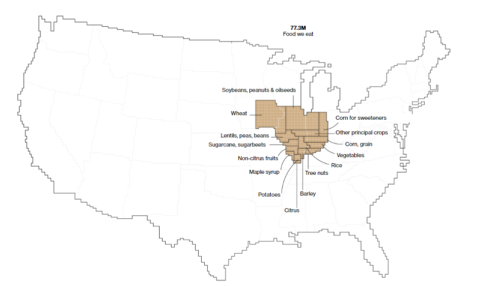
- Food we eat: 77.3M acres
- Other grain & feed exports: 62.8M acres
- Idle/fallow: 52M acres
- Ethanol, biodiesel: 38.1M acres
- Wheat exports: 21.5M acres
- Cotton/non-food: 13.6M acres
Here’s a photo of this data visualized:
Let’s zoom in on the food we eat. In the photo below, you can see wheat, non-citrus fruits, vegetables, rice, sugarcane, and a few other types of foods. Wheat, soybeans, peanuts, and oilseeds appear to be about half of what we eat. Barley, maple syrup, potatoes, and citrus are among the least of what we consume.
Featured photo by CC0 Creative Commens on Pixabay
Bloomberg data map photos are screenshots by RPS Relocation

